Update on Yeading Brook Unbound
April 2025
Environmental consultant Steve Marshall was appointed by Harrow Council to support management of this project last year and recently visited Yeading Brook to meet members of the FoYW committee to discuss future expectations. You will recollect that this £360,000 major nature recovery project is supported by the Rewild London Fund, the Environment Agency and the Crane Valley Partnership. It was awarded to the London Borough of Harrow. Commencing in spring 2024, the project focuses on c 3.5 km of the river from Headstone Manor to Roxbourne Park, and adjoining allotments/open spaces.
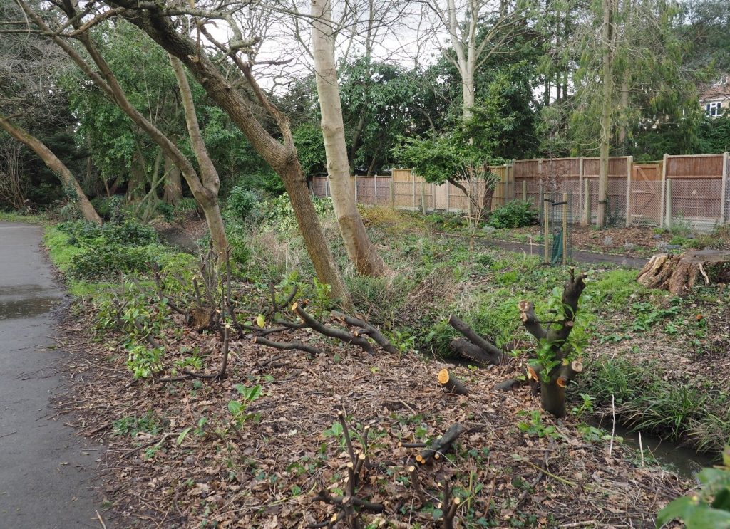
In Yeading Walk, in 2024, invasive and non-native cherry laurel was cut back along the left bank to increase light levels to extend marginal vegetation and enhance aquatic biodiversity. The bamboo was also cut to the ground and along the stream other self-seeded trees culled. In 2025, further action will be undertaken to limit regrowth of the laurel and other trees cut back last year. The invasive Japanese knotweed on the ‘island’ will be treated in summer and autumn to control it, with regular follow-up in later years, and consideration is being given to reducing the spread of the bamboo. These actions will create more space for native vegetation. Additionally, work will start on plans to enhance the brook itself through the open space. There is potential to remove some artificial parts of the bank and to re-shape other parts to create marginal habitats for wildlife. More gravel riffles can be created and flow deflectors placed in the channel edge to vary the river’s flow and create pools. Work would start next autumn at the earliest and we will give updates as the plans progress.
Yeading Brook Unbound
An introduction to Yeading Brook Unbound at Yeading Walk by Steve Whitbread , Harrow Biodiversity Officer
Although most of the capital’s water courses haven’t shared the dismal fate of the Fleet, Effra, Tyburn and London’s other ‘lost rivers’, many have been hemmed in, over-deepened, straightened, and constrained by concrete or other hard engineering intended to speed water on its way. At the same time, road run-off, misconnections and other pollution sources have dramatically reduced water quality, and this has been made worse by loss of instream and marginal vegetation, the spread of invasive non-native species and unsympathetic treatment of the riparian area and its margins, as well as more general neglect. This is true to a greater or lesser degree of all Harrow’s water courses, although there have been recent efforts to address the situation, e.g. at Newton Park West and Headstone Manor, whilst Harrow Nature Conservation Forum’s Harrow’s Streams project has helped raise awareness and enabled residents to get actively involved, building on voluntary efforts such as the riverfly monitoring at Yeading Walk which also benefits from its thriving Friends group.
Looking back
Until Harrow’s 1930’s ‘Metroland’ urbanisation – including housing along the new Lincoln, Northumberland and Suffolk Roads and the formerly rural Rayner’s Lane, the Yeading followed a rather more natural course, including through what is now Yeading Walk – although the western section, had probably already been straightened before the latter C19 where it divided fields bordering Rayner’s Lane.
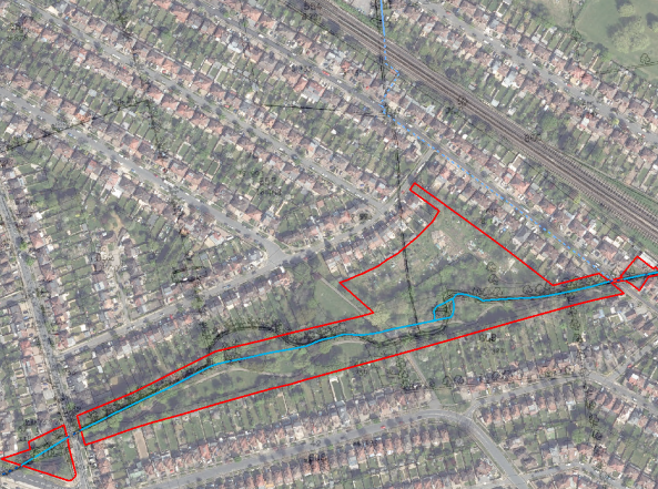
Overlaying historical maps with the existing stream (blue line) shows three major differences, with significant meanders through what now forms back gardens of part of Lincoln Road (1) and along part of the main tarmac path (2) together with a ‘lost’ tributary (3) that now runs in a pipe under Northumberland Road.
Yeading Walk appears to have been created in the wake of the neighbourhood’s development and is relatively formal in character in comparison to other parts of the Yeading Brook Site of Importance for Nature Conservation (SINC) which is of Borough (Grade II) Importance (red boundary).
Looking forwards
Yeading Brook Unbound (YBU) is a project which, working within existing constraints and taking account of future climate change impacts, is intended to make changes for the better, beginning with the western section of the stream from Headstone Manor through to Roxbourne Park. In addition to these, and some smaller allotment and open spaces the main Phase I sites are Streamside Open Space and, of course, Yeading Walk.
YBU is the first flagship project supported by the Rewild London Fund, with significant contributions from the Environment Agency and Crane Valley Partnership taking total fund support to more than £390,000 (so far). A first step to the project was a MoRPh (Modular River) Survey along most of the western arm of the Brook. Taking account of over-deepening, this found all of the stream at Yeading Walk to be in poor or fairly poor condition in terms of physical characteristics, other than the section upstream of the island which was judged to be fairly good.
Although reviving old meanders and backwaters can be hugely valuable in river restoration there isn’t scope to do anything as within such a narrow area significant here. The placement of the tarmac path so close to the river also limits what might be done here. Instead, the focus of the project at Yeading Walk will be with the existing channel, its banks, their margins and positive and negative impacts on these, guided by the MoRPh findings.
Within the over steep banks – beyond simply removing builder’s rubble and other waste- the introduction of gravel and cobbles and timber steps and deflectors, to move the water, and with it the sediment, about and build up bars and berms that could then be vegetated would not only create a much greater diversity of in-stream microhabitats but provide better shelter for invertebrates at risk of being washed downstream.
Whilst the banks are very generally very high above the water level and there is a lack of typical streamside as well as aquatic vegetation it will be possible to lower away some of the margin in a few locations.
To make these interventions worthwhile it will be necessary to both open up the stream and its margins to more light, with some well-lit areas, others with dappled shade and some remaining shady, adding to the variety of conditions This will mainly involve selective removal of non-native woody species, some of which are invasive and from within and along the stream’s. Although it is not as abundant as at some sites we will also need to control and eventually eradicate the Japanese knotweed. The increased light should allow plants introduced to the stream and its margins to establish and thrive as well as helping the water quality directly and as a result of the actions of the plants. Planting of native shrubs, which can be coppiced periodically will also add to the diversity of wildlife likely to be seen along the bank, including benefitting species living in the stream or feeding on insects attracted to it.
Some works have already begun in preparation, with the cutting down of the bankside cherry laurel to leave tall stumps that can be levered out, minimising use of herbicide where possible and preparing the way for alternatives that don’t cast such dense shade or produce toxic litter.
It is only relatively recently that the term ‘right tree, right place’ has come to the fore, partly in relation to our changing climate but also because of ill-advised planting of trees in old grasslands, peatland and beside rivers. I’m aware that the Friends hope to secure funding for the planting of additional trees around the site’s margins, partly to replace what has been lost to storms and other causes in recent years and the right trees are certainly to be encouraged. Suitable streamside planting, planning for the future is also to be encouraged and, as well as alder, we will be looking for suitable opportunities for planting native Black Poplar which is now a rarity along the Yeading.
At the same time we do plan to remove some of the trees that were planted without thought as to whether the location was right or the resulting impacts. This has prompted understandable concerns about bat roosts, and we have paused the works begun in February. Certainly no tree either known to have a roost or with good potential for roosts will be removed in connection with the project, some of the oaks and willows probably fate back to when it was still ‘all fields around here’, after all. Whilst the only large trees we would be planning to remove aren’t of a species favoured by bats, an inspection by a suitably experienced bat ecologist will be commissioned to provide the necessary reassurance.
As for what happens next at Yeading Walk, there will be some hiatus whilst we look to appoint specialist contractors and work with them to agree details, working within the available budget. For works affecting the stream itself we will need a flood risk activity permit (FRAP) from the Environment Agency, whose staff will need to be sure there will be no increased risk of flooding. Beyond securing Agency approval, there are two critical parts to the design process. One will be to ensure that what is implemented will be able to stand up to the relatively high flows of water during the winter, as has been very much the case this year, whilst also making sense when there is very little water, such as in summer 2022. Both winter wet and summer drought will be increasingly common, and we need to design around this. Secondly, it will be critical that the purpose and value of the project as a whole and for each of the sites and communities that it involves is adequately explained and consulted on, so that it will not only be understood but actively encourage and facilitate participation. This is why, beyond the more major works to be undertaken by contractors a proportion of the budget is to be retained to support to follow-up community and Friends group works, seeds and plants, training and events and a management plan drafted to help guide activities.
The intention is that without affecting the wider area of the park and all the positive works that have gone on here in recent years, the stream itself should be in much better condition, which will have downstream benefits as well make it richer in wildlife and more appealing for visitors of all ages.
In the meantime
We are working with ZSL to produce a vision document for the western arm of the Brook, which will explain more about the YBU Project objectives and support the consultation process over the spring whilst we turn these into detailed plans (Ahead of this being released you might like to see the vision for the re-naturalisation of the Lower Crane much further downstream in Richmond).